
7.1 The breadbasket of Siena
The beauty of Val d'Arbia, from Siena to the Cuna grange
‘When it had rained heavily, the Tressa could be heard roaring from the threshing floor; the plains were flooded; the damp poplars and worked clay glistened. Of Siena, behind four or five ever-higher hills, almost spiralling, only the walls could be seen between Porta Romana and Porta Tufi. From the walls, the meadows and the wheat fields descended, cut by a few roads; reunited in segments, they led towards a few farms; with the houses on the hilltops, surrounded by cypresses. You could hear the train from the Val d’Arbia; according to the farmers, it was a sign of rain’.
(Federigo Tozzi, Il Podere)
Porta Romana looks towards the Val d’Arbia and then beyond, in the direction of the Val d’Orcia and ultimately to Rome, from which it takes its name. Once through the gate, leave the walled city behind and start pedalling along what was once the Via Francigena-Romea, the road of which ‘Siena is the daughter’, as the historian Enrico Sestan wrote in a detailed synthesis of history, economic development, and territory.
Once in the open countryside, follow the signs for ‘Francigena sud’ along a route that will take you as far as Cuna before turning back along a different route up the hills on which the City of the Palio lies.
Taking the Strada di Certosa, you will come upon the beautiful Certosa di Maggiano along a route that is far from heavy traffic and runs towards the Val d’Arbia, alternating between easy climbs and equally easy descents.
Ⓒ_mooos_taverne_
Siena is now behind you and, if you stop for a moment, you can admire all of its breathtaking beauty. As the Sienese writer Paolo Cesarini wrote: ‘From up there, the city appeared like a gift, lying long and rosy on the hills with its yellow-tinged towers and its cathedral shining white above’.
The road becomes unpaved for a short stretch (be careful because the descent is partially uneven) and, at a small fountain, it becomes a cycle/pedestrian path for a few hundred metres before continuing on (follow the signs for Francigena sud) to the industrial area of Isola d’Arbia. A short stretch of the Cassia leads you to the hamlet of Isola d’Arbia, a town located along the medieval pilgrimage route as evidenced by the beautiful church of Sant’Ilario. You are now in the middle of the Val d’Arbia, the historic breadbasket of the Republic of Siena, which is still devoted to the cultivation of wheat.
Just after Isola d’Arbia, on the side of a short cycle/pedestrian path adjacent to the SS2 Cassia before Ponte a Tressa, stands an unusual building in an obvious state of disrepair that is difficult to miss. It is the former Idit di Isola d’Arbia, an industrial factory that was inaugurated in 1960 in the presence of the most prominent political and religious authorities but which was practically never put into operation. The 50-metre-high structure, made of iron, glass, and cement, was intended to produce freeze-dried tomatoes and was a clear example of an innovative factory. One month after its inauguration, it permanently ceased operations.
The remaining silo has been the subject of debate for decades among politicians and citizens alike, with petitions and requests to demolish it never going through, both because the project would be too costly and because the structure is considered by some to be a ‘testament to industrial architecture’. The tower, a failed attempt to industrialise the area, stands out from the surrounding countryside. This ‘eco-monster’, abandoned and in a state of extreme disrepair, has paradoxically become part of the landscape of southern Tuscany, and various proposals have been put forward for its reuse: to turn it into a tourist accommodation facility, or a centre equipped for cycling tourism given its location along the Via Francigena, or even—and this Is the most recent—to transform it into a contemporary art museum.
Thus you arrive at Ponte a Tressa, formerly known as Sant’Angelo a Tressa.
At Ponte a Tressa, leave the busy SS2 Cassia to turn right at the traffic lights and then, after a few hundred metres, take a charming macadam path that intercepts the cluster of houses surrounding the Grancia di Cuna, the imposing red brick structure that dominates the area. The off-road track zigzags through flat or slightly rough terrain, devoid of trees, right at the foot of the gentle hills that climb up the Crete Senesi, dotted with sparse farmhouses. You are now on the outskirts of Monteroni d’Arbia, an important town in the valley of the same name, which you will pass through on another route.

Ⓒcvctales
Cuna is the southernmost point of this itinerary, and there are 2 different routes you can follow to return to Ponte a Tressa. One, a little longer but with absolutely no traffic, is along the unpaved road you rode before; the other, shorter, is on the SS2. Once in Ponte a Tressa, proceed along the Cassia to km 219, then take a right along the Strada Comunale di Fonte Murata to the Renaccio area. Here, when you arrive at a roundabout, follow the signs for ‘Firenze – Siena – Grosseto’ and pedal uphill for just over two kilometres. This is the only rough road of the day, with an incline that is never particularly difficult and which will lead you back to the main road.
Siena rises above the horizon with its unmistakable profile, ‘divided’—to quote Paolo Cesarini again—’perfectly from the countryside by the regular barrier of the walls’.
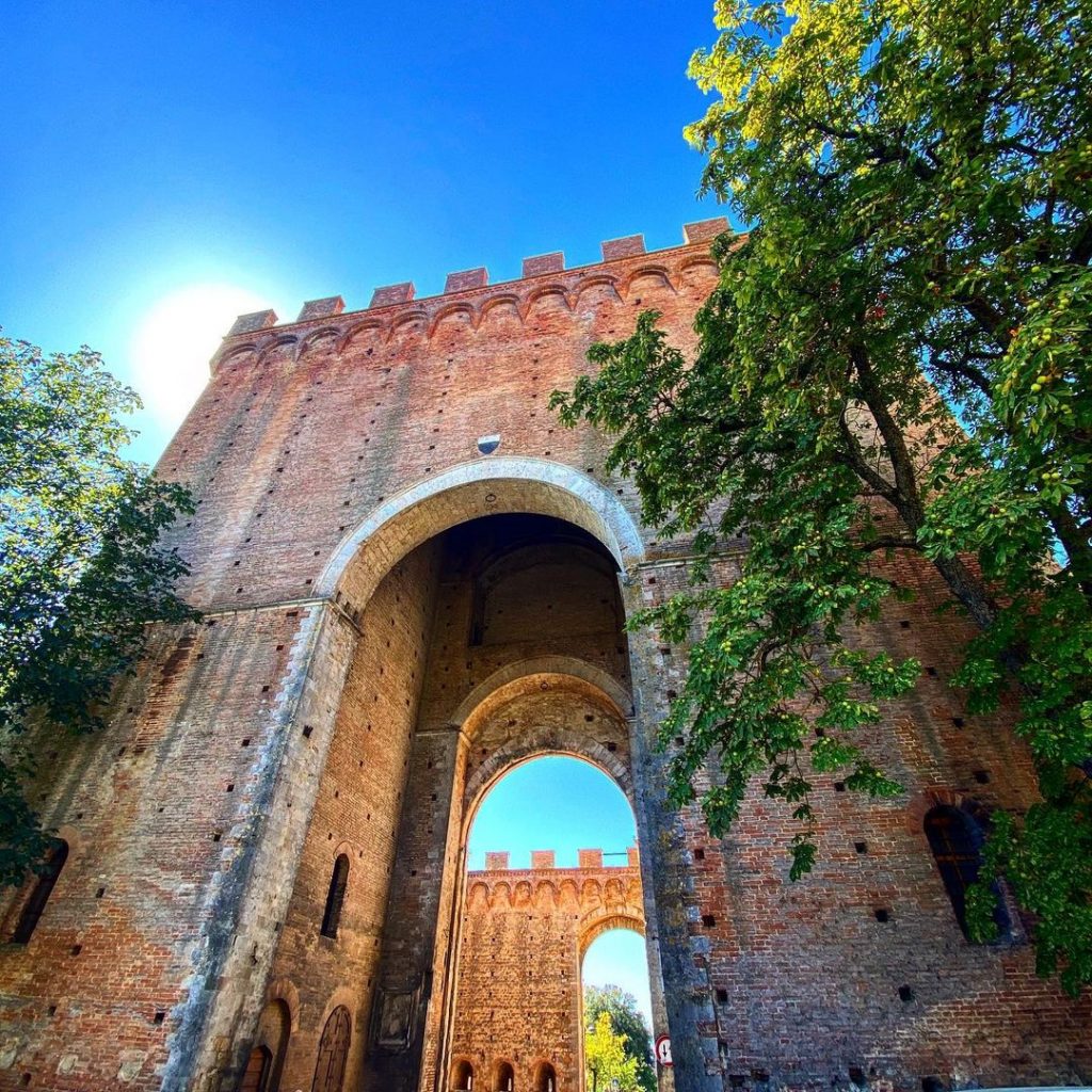
Before arriving at Porta Romana, at km 225 of the Cassia, we would like to point out the complex of Santa Maria a Bellemme, a medieval church and hospital for pilgrims along the Via Francigena, which was constructed before 1236 and run by the monastic-chivalric Ordine dei Betlemitani, also known as the Ordine dei Crociferi, founded in the Holy Land in the 12th century and active until the 17th century. In the past, the church took on specific importance because of the link between it, the Church of the Nativity in Bethlehem and the episcopate which, after the conquest of the ‘Oriente crociato’ (the Kingdom of Jerusalem), had its seat there.
The construction of Porta Romana, a monumental gateway, a sort of ‘visiting card’ of extraordinary elegance and beauty for those arriving in Siena from the south, was part of the plan to extend the city walls designed by the Governo dei Nove at the beginning of the 14th century. Completed in 1329, as confirmed by the plaque with the Balzana (the coat of arms of Siena) embedded in the wall to the left of the main archway, the gate fulfils the role of ‘civic representation’ that the city government wanted to assign to the new gates, such as Porta Pispini, built at a time when external dangers were less pressing.
When the work was completed, the construction was so majestic that Agnolo di Tura del Grasso, author of the ‘Cronaca senese’ (‘Sienese chronicle’) around the middle of the 14th century, described it as ‘great and beautiful, more defensive than any gate in Italy’.
This remained the main concern of the Sienese rulers, who at various times took measures to enhance its beauty and protect its visibility. To this end, in 1408 the Consistory ordered the demolition of the nearby convent of San Barnaba as it obstructed the view from Valli, and in 1484 the Consiglio Generale decided to demolish a portion of the small hospital of Santa Caterina delle Ruote, which most likely jutted out onto the road (the present-day Via Piccolomini), obscuring the view of the surrounding countryside ‘which can then be seen with the eye from the gate looking towards the valley, which in truth will be beautifully suited and ornate and useful for many respects’.

ⒸLigaDue
Again with a view to enhancing its beauty, the gate was decorated and embellished with the fresco on the large aedicule of the tower, which depicts ‘L’Incoronazione della Vergine’ (‘The Coronation of the Virgin’), commissioned and begun by Stefano di Giovanni, known as il Sassetta, and completed by Sano di Pietro following the former’s death.
The foundation of the Certosa di Maggiano dates back to 1314 when Cardinal Riccardo Petroni, a Carthusian monk from an extremely wealthy family, decided to build a place reserved for meditation and prayer. But in the same year, 1314, the cardinal died and his executor and cousin, Bindo Falcone, started work on the monastic complex in 1316, which over time became an important centre for spiritual retreat. In 1554, during the Spanish-Medicean siege of Siena, the Carthusian Monastery was set on fire and largely destroyed, although it managed to exist until 1782 when the Grand Duke of Tuscany, Leopold II, decided to demolish the seventeen cells of the monks and sell the entire complex, excluding the church which became a parish. In 1969, by then privately owned, a total renovation was undertaken by Renzo Mongiardino, an Oscar-nominated set designer and architect, with the aim of combining the historical tenor of the place with that which has become its current function: a luxury hotel with seventeen rooms, just as the friars’ cells had numbered seventeen.
The small church of Sant’Ilario is characterised by a Romanesque façade decorated with two-tone arches and a bell gable. The vault of the portal is also bi-coloured, while a small window in the shape of a cross opens above the arches. The symbols on its façade have been much debated: a flower (or cross?) is carved on a block of stone embedded in the masonry at the top right, next to which is a zoomorphic scene; a cross is also carved in the centre of the archivolt of the portal. As one of the many places where pilgrims stopped, it was customary to leave ‘distinguishing marks’ at various points along the route to prove that the journey had been made. The best known is the ‘shell’, left by those who had been to Compostela; a palm tree was left if the pilgrim had gone to the Holy Land and likewise for every place of worship and devotion visited.
The Val d’Arbia
The Val d’Arbia is an alluvial valley floor marked by the meandering course of the Arbia River, a major river artery along which important urban settlements have sprung up over time, bearing witness to the fertile vitality of commercial traffic. In the Middle Ages, trade, agricultural production, and the use of energy resources developed on such alluvial plains. The waters of the river were channelled into a complex system of gorges to be used for agricultural production and to feed paper mills and mills, the latter linked to the elaborate network of grain mills, the most significant example of which is the Grancia di Cuna.
Today, one of the resources of the valley and surrounding areas is the production of Val d’Arbia DOP (Protected Designation of Origin), which includes white, rosé, and Vin Santo wines.
Ponte a Tressa,
Ponte a Tressa, a settlement since Etruscan times, experienced its period of utmost splendour beginning in the 12th century, as attested by documents indicating the presence of a castellare (a fortified borough), no less than two churches, a ‘spedale’ (hospital) and one or two mills. Tressa was later one of the so-called comunelli of the Masse del Terzo di San Martino di Siena and the centre of the first important donations of property to the city hospital of Santa Maria della Scala, into whose hands also fell the historic hospital of Tressa, built in 1219 by the banker Ugolino Quintavalle. The present church of San Michele Arcangelo or Michelangiolo, formerly dedicated to the Madonna, was located next to the old pilgrim accommodation along the Francigena.
It was mentioned above that Ponte a Tressa was part of the ‘Masse di Siena’. Since this denomination will often recur in the various itineraries, it is only fitting to specify that the Masse di Siena was the strip of land around the walls of Siena with a radius of six to eight kilometres. From at least the 13th century onwards, it enjoyed a special juridical-administrative status and was divided into three autonomous communities, corresponding to the three Terzi into which the city was territorially divided: The Community of the Masse del Terzo di Città, that of the Masse del Terzo di San Martino, and that of the Masse del Terzo di Camollia.
The territory of the Masse, studded with hamlets, villas, and cottages, was made up of small farms and intensively cultivated orchards, constituting a sort of buffer between the city and the countryside, from which it continued to differ in its customs and way of speaking until after the First World War.
The jurisdictional reform carried out by Pietro Leopoldo (Leopold II) on 2 June 1777 suppressed the Community of the Masse del Terzo di Camollia, dividing the 17 Comunelli (i.e. the small settlements that comprised it) between that of the Terzo di Città and that of the Terzo di San Martino.
Grancia of Cuna
In the 19th century, Giuseppe Merlotti, in his ‘Relazione storica di tutte le moderne e antiche parrocchie della campagna comprese nella diocesi di Siena’ (‘Historical report of all the modern and ancient parishes in the countryside included in the diocese of Siena’), described the village of Cuna as follows: ‘Along the left side of the strada Romana, on the slopes of a delightful fertile hill and at the beginning of the Piano della Val d’Arbia, lies the church of Cuna, with its grand palazzo, which was one of the grance (granaries) belonging to the Spedale di S. Maria della Scala di Siena’. In the 11th century, there was a xenodochium (a sort of hospital and hostel for wayfarers) and a church located in this area. Then, in the 13th century, the entire territory came under Sienese control, and a farm located on the ‘poggiarello di Cuna e Castelluccio’ was donated to Santa Maria della Scala di Siena, which decided in 1314 to build the mighty fortified estate (called ‘grancia’) that still dominates the territory today.
Cuna administered houses, farms, shops, dovecotes, brick and lime kilns, mills, and taverns, and served as a storehouse for the wheat, flour, and cereals that flowed in from the entire surrounding area. It became the city’s main supplier of grain and also served as a reserve storehouse in case of epidemics and famine.
In 1366, the grancia was fortified with walls and a permanent armed garrison; in the 15th century, a second ring of walls was built, of which the main gate and the tower remain intact, enclosing the farm and the entire village that developed around it.
Precisely because of its location along the Via Francigena, Cuna hosted popes and kings: Urban VI in 1386, Martin V in 1420, and Paul III in 1451. Charles de Lorraine, 4th Duke of Guise, died there in 1640, and legend has it that his viscera still rest in the village church, dedicated to Saints James and Christopher, which houses the remnants of 14th– and 15th-century frescoes, including one depicting Saint James the Greater and Saint Ansanus (the patron saint of Siena), attributed to Taddeo di Ruffolo, also known as the Maestro dell’Osservanza.